The vickers can see thru sight blockers to the left? Explain please. In testing the vickers could not see the left side of the map.
Sappers come with a super fun ability to just remove the hedges.

 United States
 United States
Thread: Angoville Discussion13 Nov 2018, 02:21 AM
Sappers come with a super fun ability to just remove the hedges. |
Thread: Angoville Discussion13 Nov 2018, 02:05 AM
It has no value cause the cutoffs are not symmetrical and the current layout is unbalanced favoring the north. |
Thread: Angoville Discussion13 Nov 2018, 01:56 AM
Purple hedges need to be placed along the building to the north to afford the same opportunities, and the building moved in. This also should lead to the south east cutoff being put in the north east. OR You put the buildings on the other side of the road from the north end to mimic the cutoff and its layout in the south east. (which would just make two buildings to rush instead of one), but at least than it would be fairer. Never ever put large trees in a map ever. They should all be deleted out of all maps. They aren't even heavy crushable. So I agree with removing them. Sight blockers on the west would need testing, but should allow you to move along a bit better... BUT it would still favor axis largely. |
Thread: Angoville Discussion13 Nov 2018, 01:47 AM
Cutoff layout like this makes games last less than 5 minutes and then this vp layout make games last more than 1h LUL IMO the VP layout is not a problem as much as where they are located on the map and their surroundings. You have plenty of maps that have "safe" VPS, and you could move them a bit futher back so they are not so close to one another, but they are typically in a straight line down the middle. This really boils down to because it is easier to lay a map out like this. The real issue is the fact that they are located on the far side surrounded by buildings, and have an asymmetric cutoff layout that directly favors one base over the other. Like I said, I think a new map with this layout and some changes to buildings and LoS blockers and the map will be fine, this will also allow us to help mitigate the negative cover retreat path and some of the height issues. |
Thread: Angoville Discussion13 Nov 2018, 01:35 AM
Biggest problem IMO is just the general asymmetric sides of the map. One side being heavily litered with sightblockers, garrisons, etc while the other is more open. The VP problem still persists though, regardless of whether or not you go left and are able to capitalize on more resources, you are still required to go right inorder to capture VPs. This gives an noticeable advantage to the faction that can clear garrisons without much struggle(EFA). All you did was agree with me LUL. But with a specific example. And yes, the vet 1 vickers in any garrison is a pain cause it sees so damn far, but lets be honest... do you really ever see brits on this map? And we could really start to split hairs here and say, is this a faction balance problem, map balance problem, or a bit of both?
Well I proved what you are saying with the the symmetric vs asymmetric argument almost 3 years ago. |
Thread: Angoville Discussion13 Nov 2018, 01:10 AM
This post pretty much describes Angoville problems imo. South cutoff building still problem. Specially for those factions that dont have a non doctrinal flamethrower. I want to add that the elevations still a problem, and for some reason new sightblockers have been added in some annoying spots Sight blockers come after whether or not it is worth making a new map. I should've added a poll. I'd rather just see a new map altogether designed after angoville from Rosbone. As I think he would do a good job, the issue is communicating that to Andy. |
Thread: Angoville Discussion13 Nov 2018, 00:53 AM
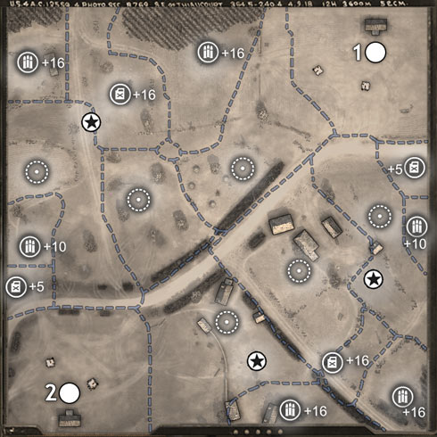
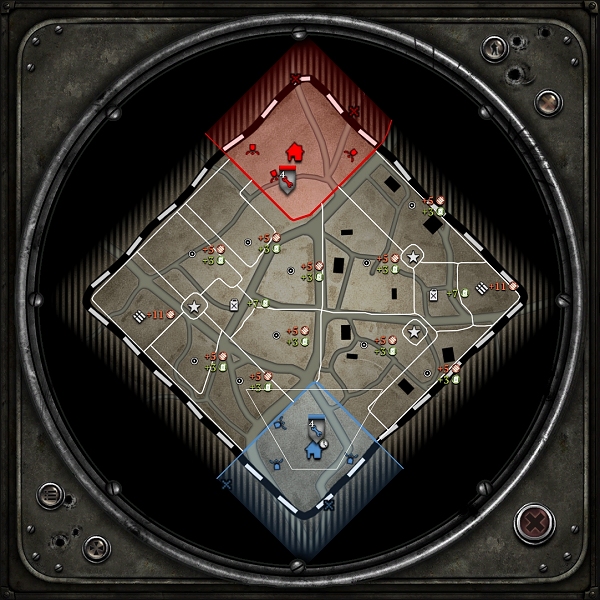
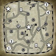
Making this to move the discussion out of the shoutbox. VCoH Angoville  With the lack of Truesight, and the older mechanic of high/medium/low muntions/fuel points, this creates several issues. The main play around this map was always about defending your cutoffs to keep your fuel income up (while harassing your opponents) Playing from the North was favorable if you could secure the cutoff in the southeast to block your opponent off. The inverse was true for the south, as they would want to take the cutoff to the north west, however with no building watching the cutoff, it was far easier to hold. Therefore the dominant play was always around the south east cutoff for BOTH players. If North grabbed it and held, it would net them map advantage, and then transition into a tech advantage. Old Angoville Coh2  Important to note: Right side has 5 territory points, 1 fuel, 1 munition, 2 vps Left side 5 territory points, 1 fuel, 1 munition, 1 vp New Angoville CoH2  New layout has many things changed, buildings, sight blockers, and territory points. Right side has 4 territory points, 1 fuel, 1 munitions, 2 vps Left side has 6 territory points, 1 fuel, 1 munitions, 1 vp Also important to note that the cutoff in the south east still exists, and it still has a dominant building right on top of it. The cutoff "mimic" in the north east now has the same thing. HOWEVER. The northern cutoff is far more ineffective as it does not overlook the actual cutoff that it does in the south. This leads to dominance from the north base, as they have more tools that are far more effective from the map itself to cutoff the south spawns resources in the east. Also important to note the the LoS blocking medium crush wall in the south was removed and than mimicked in the north (good change imo). Now depending on faction, you will never want to go to the east if you lose the first engagement. There are far more resources on the left side. This might sound good, but it actually lends itself to axis. As the western side is primarily long to medium range engagements. This would also slightly help out brits, but since they have no native garrison clears... most brits would be vetoing this map regardless as it has 8 garrisons (one garrison on the minimap can't be accessed), therefore it has 2 less than the original port. The other thing is that in the west the northern base ALWAYS has a free point connected to their base, even if the cutoff is contested and the south does not. Slightly favoring the North side. This is compounded by the fact that if they lose the south east building near their cutoff the also lose the entire east side. Whereas the north does not. So overall the map will favor north spawns, and devolve into rushing the cutoff buildings. Below is a picture to clarify what I am talking about.  (important to note I am showing how the territory SHOULD be in the east, but it isn't for some reason, it also could be in the south west mimicked like this, as another option.) This issues, are multiple for me on this map, as I detailed above (bear with me it is late for me and I tend to ramble in long posts). I am sure I missed a few things, but I really can't remember the last time I played this map (where the game wasn't over at 20minutes), so I am trying to talk to the multiple iterations it has had this far. Not that it can't be fixed. Is that it is no longer angoville with these changes (lost its soul as I say). It SHOULD be an all new map, done by the person that did the work on this. (aka Rosbone) As to my knowledge these are changes he wanted to make and was told no by the powers that be. |
Thread: Help me hans8 Nov 2018, 18:59 PM
Solid 5 year necro. In: Mentoring |
Thread: CoH & AoE4 coming to Xbox? 5 Nov 2018, 01:27 AM
Yah. The hype for AoE4 has long since faded. HOWEVER I am very excited for the wc3 remaster. In: Lobby |
Thread: CoH & AoE4 coming to Xbox? 4 Nov 2018, 22:52 PM
What's also scary about this is that they have a total of 2 titles on console ever. https://en.wikipedia.org/wiki/List_of_Relic_Entertainment_games So its largely uncharted territory for them, but you can't really blame them for wanting a piece of the pie that is console gaming. In: Lobby |
 |
|
|
19 |
 cblanco ★
  보드카 중대
  VonManteuffel
  Heartless Jäger

