Hello chaps! So, I can't imagine many of you know who I am, but alongside Maxi, I was one of the mappers for the Eastern Front, and with all of the enjoyment I got out of working on the mod, it seemed foolish to not try to recreate some of my favourite maps for our new Overlord.


Release Version:
Version 2.0
Below are the Beta links for Vyazma:
Version 1.0
Version 1.1
Version 1.2
Move the sga into your "my games/company of heroes 2/mods/scenarios" folder to play!
No minimap or loading screen is currently attached. If you encounter any issues, please drop a message!
Version 2.0:
- Wooden bridges removed and water crossing fixed.
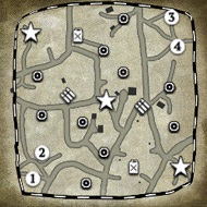
- Loading Screen and minimap added.
Version 1.2:
- Positions 5 and 6 added, making Vyazma a (4 -6) player map.
- Weather settings adapted (less fog, more rain).
- Fx added to increase the amount of burny stuff.
- All territory completely fixed now, and all manpower points can be upgraded.
- Territory on Southern side of the map has been moved to facilitate new bases.
- Grove on South-Eastern island removed to allow easier travel through the forest.
Version 1.1:
- Old manpower flags replaced.
- Outdated shot blocking replaced.
- Additional cover added to particular areas.
- Weather settings updated.
- VP's rotated to allow vehicle movements.
- Wrecks added to offer temporary green cover.
Version 1.0:
- Basic Territory put in place.
- Basic weather settings in place.
- - - - - - - - - - - - - - - - - - - - - - -
[Old Post]
So, without further delay, I present to you the 33% completed recreation of Vyazma!

(Note that this minimap still has the old "blockers" on it, which appear orange. Additionally, the western island and the central island have yet to be touched).
This map was originally designed for 4 players, with rural outskirts to an easily accessible ruined city. Thanks to both my mapping methods and the amount of removed textures/objects from WB2.0, much of the map has been scrapped and rebuilt.
However, with many new beautiful additions, I will hopefully be able to improve the visual quality of the map. In the screenshots below, you will see the completed areas of rural and forest outskirts, which will form the major flanking point of the map.


More updates are coming! Keep your eyes peeled! Any feedback will be greatly appreciated.


 United Kingdom


 cblanco ★
  보드카 중대
  VonManteuffel
  Heartless Jäger