Hi Seb,
Thank you for the response. So the units' state are actually simulated in game. Does the replay store data to make sure that random RNG moments are recorded and reproduced when the replay is played?
Where in the replay data does the actually replay stop? As in where does it end?
Thank you again.
Assuming that coh1 replays work like coh2 replays (and Seb´s description sound like it does):
Every computer RNG is actually only a pseudo-RNG. You have to "seed" the generator with a number. Seeded with the same number, you´ll get the same sequence of "random" number. The replay files do contain that seed, so when replaying the replay, each event that requires some RNG role will give the same result as when the game was played originally. Like, the units will hit, miss and penetrate like they did originally.
After some header, the replay basically contains only the commands of the players. So, the replay file ends when the players stop issuing commands. This also means that the file does not even contain explicitly why a game ended and who won. That is, unless one of the players issued the "surrender" command, which is stored in the replay as well. |
Thanks guys!
I genuinely wish, as a mapper, there was some way to get live data from relic on all of these statistics to better develop and understand map dynamics, balance, likability and quality. Relic should seriously consider this when they design their next COH game...
Well, the data is kind of from the perspective of the players; I guess as mapper you'd like to have some more numbers.
I would be interested to see in particular how the win percentages for the starting points differ, but those don't seem to be in the data packages that I retrieve (at least I couldn't find it and I tested some options...).
I could do win percentages for different matchups, though...
Suddenly I come to understand why Lorch is so god damned hard as axis
Unfortunately, the post doesn't tell you the "why", but yeah, it's not you 
Nice article, how did you get this data exactly, is it publicly available somewhere?
Sort of. A bit simplified, I have a script that retrieves the game history for each player on the ladders twice a day (it uses the API that the official leaderboards use to generate the history when you click on the "recent matches" tab there). The data packages that you get contain somewhat more information than what is displayed under that tab, for example the map name.
|
Because vetoing it doesn't work.
Yes, there were reports of people getting Steppes even though they vetoed it. However, it seems unlikely that that's the (main) cause for Steppes appearing more than twice as often (a little more than 20% recently, vs. 8.6% before).
Edit: I base that on the fact that the least vetoed maps end up being played in around 10% of the games and I suspect that simply not vetoeing a map can't get it up to 20%. For example, Rzhev Summer in the 3v3 pool is definitely not vetoable, yet still it is played only a little more often than Across the Rhine (8.2% vs. 7.3%).
My guess is that the place of Hill 400 on the server list of maps now went to another copy of Steppes, so that the chance of getting Steppes is twice as big.
I don't think the numbers are accurate enough to conclude how vetoes are currently working regarding Steppes (given that it wasn't vetoed as often before). It might be that the veto indeed doesn't work for Steppes at all. Or it still works for the original Steppes, but not for the "Hill 400" copy of Steppes.
Amended the section accordingly... |
Hey ho... I didn't spend much time on it but I tried several [] to get them visible without success. If one of you is kind enough to explain...
The problem is that the links do not refer to the pictures directly but to steam pages that contain the figures.
To get a picture up here you only need the img tag. The url tag embeds a link on which you can click. So, if the link would actually be a picture, the picture would appear and clicking on that picture would direct you to that link. However, in this case the stuff between the url tags can't be interpreted so there is no link.
What would work is either to upload the figures here and then use the img tags.
Or:
[url=http://steamcommunity.com/sharedfiles/filedetails/?id=874738776]Note the 2 barrels close to the MG nest[/url]

[url=http://steamcommunity.com/sharedfiles/filedetails/?id=874738794]Crushing party[/url]
gives
Note the 2 barrels close to the MG nest
Crushing party
|
Sorry I wasn't subbed to this and it weasled its way to the bottom of the page so I missed your post 
You have to use the impass editor tool. It is the icon that looks like a traffic light.
(also I subbed to this, and feel free to pm me with other things if I miss something.)
No worries, man, thanks for the reply. I found the solution I was looking for. I tried the impass editor tool and while that indeed keeps units from walking into these areas, it's not exactly what I was looking for because it doesn't produce the sort-of-dashed line that surrounds that area on other maps.
However, after some more googling and trial-and-error, I found this thread, so the answer is the "Interactivity stage editor". Not really intuitive, huh?
Another question: I noticed that outside of the playable area everything is just black, no textures or anything. Is it always like that or is that something one can change in e.g. the Atmosphere properties? (no problem if it is always like that, just wondering...) |
Ok, I got a little further now. Far from finished but I thought I could try out some of the things I made versus AI.
Now, when setting up the map I stuck closely to what Unlce Sam's tutorials, including the dashed line around what I thought would be the area in which units can move around:

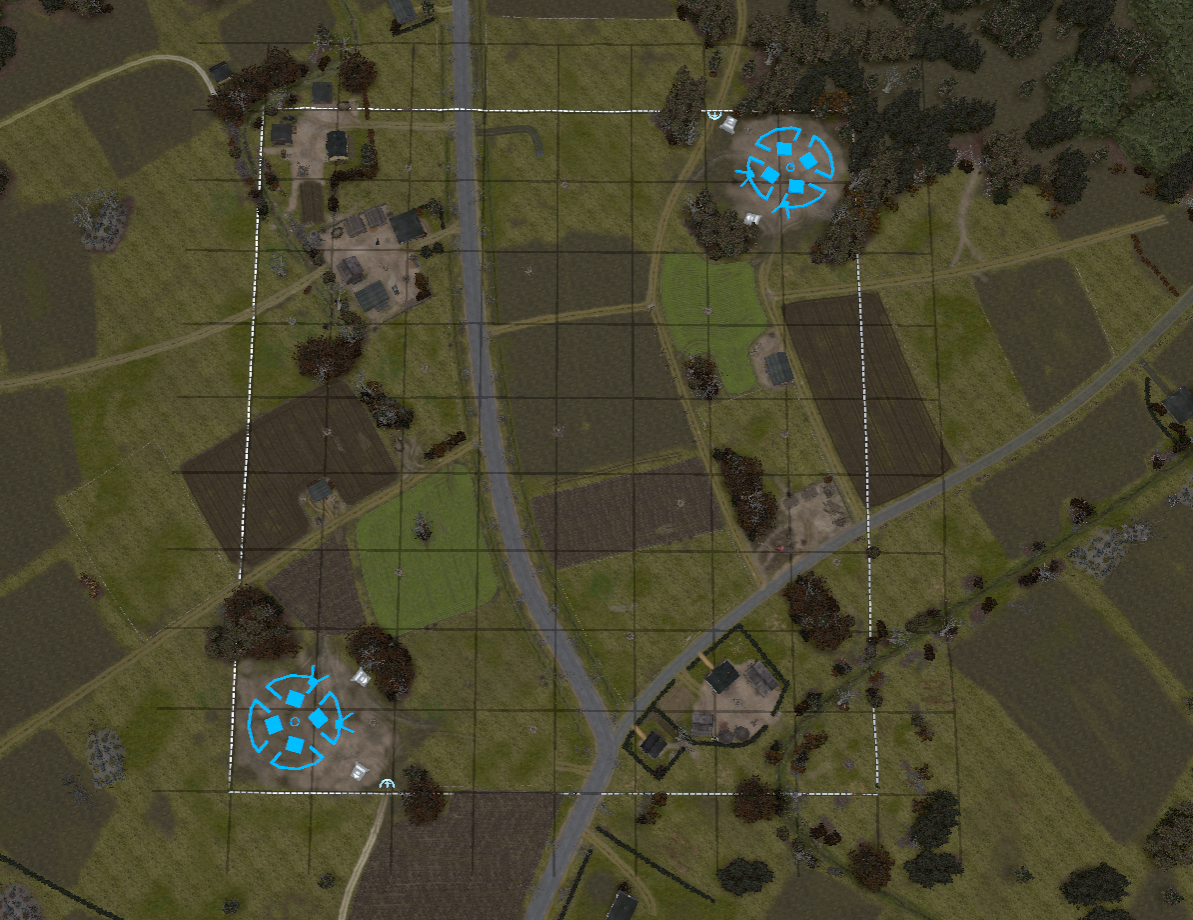
This is my map (yeah, not finished of course) in top view, with the 32 m grid.
I was a bit surprised to find that units could move all the way to the outer edge of the 32x32 grid, so seems like I have to set the allowed area somehow (also makes sense given that there are maps with a clear non-rectangular shape in the map pool.
So, how do I fix this? |
|
Thanks guys!
And yes, it was the "On snow" switch... |
1.) Control + Page Up / Page Down, will sort them to the top or the bottom of the layer. You can also use the up and down arrow keys to move up and down at 1 increment, but depending on how many you have used, there will be a lot.
Uhm, just played around with splats (btw, is there a way to make them appear in their "optimum size" right away so one doesn't need to click on that button?).
While the Control + Page Up thing worked nicely with the texture splines, it doesn't seem to work with splats. Do I fail to smash the right buttons or is there some trick to this? |
Thanks Tric!
Also when it comes to buildings, you can only use 1 major tileset. AKA industrial, rural, or urban, if you don't this will cause lag.
Oh, that's a bummer... |
|
I started to look into creating maps now. Great guides on here. I have a couple of questions, though:
1) I'm using splines a lot. Now, when I have texture splines stacked, is there a way to influence their order? Like, at times it seems like I click on one of them and then something that was on top suddenly is invisible and so on...
2) Where can I set the amount of fog?
3) Regarding cover: Things that modify cover are objects and textures only, right? Like, if I create a step in the terrain elevation, that will not create cover by itself (yeah, it will have some influence on scattering shots, but not cover per se). So, a ditch will not have cover because it is a dent in the terrain, but rather because of the ditch texture put in, right?
I guess that cover from objects is directional while cover from textures is not. So, two units in the same straight ditch will have cover modifiers on them, even though they shot each other along the ditch?
I'm working on a map recreating the situation around the village that I grew up in, Winnekendonk. It was attacked by the British 3rd Division on the 2nd of March, 1945. Some Fallschirmjäger, parts of the 8. Fs.-Jg. Division, tried to delay the advance of the British.
I'm attempting to stay close to how the landscape there really would have looked, but it's kind of tricky mostly for two reasons:
1. Most trees and bushes at that time of year have no leaves yet (they still might have some brown leaves left over, though); on the other hand there was no snow, it was pretty wet and muddy. There are not that man plants that have no leaves but also no ice or snow on them...
2. Almost all buildings in the area are made from bricks, with a few with plaster. There don't seem to be any rural/farmland brick buildings available (although some of the industrial buildings probably work).
I guess there is no way to at least recolor (or retexture) the models in the worldbuilder, or is there?
|


 Germany


 VonIvan
 Burmie
 Burmie
 VonIvan
 Insane DevM


