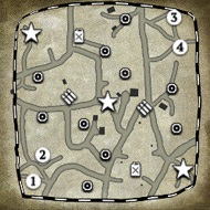
And the start position was original thoughts to be in each corner, but then it will take a longer time for the action to start. Thus the 2 different start position for each team.
The red arrows are path over water and the blue lines are path through the terrain....Now all the small cannals can be acces by infantry, so you can climb wall with them and run in the small Irrigation cannels.


These are the Irrigation cannels that the infantry can climb in to, they are around most of the farme fields, I know the Computer A/I will not be able to use them, but the map is for Human against Human and thus , you can move all over the map if you climb in to the small Irrigation cannels


Ex samples of the Irrigation cannels that infantry can climb in to:


 cblanco ★
  보드카 중대
  VonManteuffel
  Heartless Jäger