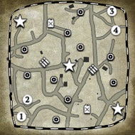
A map I've been working on the last few weeks. It is a work in progress, but at a point where I am comfortable with people being able to see it.
The map is mostly complete from a design standpoint, but I am always willing to listen to feedback. The purpose was to create a long, horizontal corridor for maximum flanking and maneuvering potential. I may potentially convert or create a 3v3 version, but only after I consider the map 'complete'.
The map features a number of rocky ditches and roadside trenches that provide yellow terrain cover.
I am particularly interested to see how well my experiments in the logging area in the northeast hold up for people, especially the log-trench.
The red cover on the map is outlined with animal corpses and a few bloodstains, as a visual cue.
Also, the VP cap circles are red cover.
The aesthetics that I have barely touched yet and will continue to chisel away at:
Road trims/transitions
Grass trims/transitions
The sandbag positions
Bush/shrub/hedgerow blob conversion into more varied objects.
I chose the name "Itter Fields" because there's a lot of fields and the Battle for Castle Itter is a fascinating story. I'll put a castle in the OOBs eventually.
All the fancy tac map stuff and such will be the final step in the process. I'm also aware of the large map borders. That will be changed in the final version of the map.


 cblanco ★
  보드카 중대
  VonManteuffel
  Heartless Jäger